Vertical Circle
Generates vertical circles for drone navigation
Description
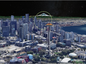
This application generates circles in the vertical plane (perpendicular to the surface of the Earth); used primarily for composing drone flight paths.
Instructions
- Enter information into each of the fields below
- Click the [Calculate] button
- The application will return a .kml file (Copy or Download) and map displaying the results. (Note that the result will appear as a line on a 2D map.)
Inputs
Notes
This is a custom application requested by a drone enthusiast for use with Litchi flight planning software.
It is important to note that I have not placed any restrictions on the size, placement or orientation of the output, leaving it up to the user to verify that any flight paths created using this application will not violate any applicable laws or regulations, or result in crashing the aircraft.
Also note that the Digital Elevation Model (DEM) used by Litchi or other applications may differ from that used in Google Earth.
Stay safe and have fun out there!
See also:
- KML Workbench Merge LineStrings
- KML Workbench Reverse
- Ed Williams' Aviation Formulary